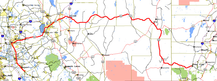
Click on map for larger version (1464x549)
The original plan was to visit Yosemite today, then head back to Oklahoma tomorrow. But with that same upper level low that gave Sacramento the tornadoes stuck in place over the Southwest, I became concerned I was going to need some extra time to get back. So I headed out early, leaving Turlock at 6am. I also took a slightly different route back as well, similar to the one I took in May 2003. Instead of taking the usual Hwy 99/Hwy 58/I-40 route, I took US 50 east out of Sacramento. This route took me over the Sierra Nevada, where there was just tons of snow above the 6500 foot elevation. Snow was piled at least 7 feet high at Echo Summit, where highway signs were partially submerged and it felt like driving through a canyon of snow.
Shortly after crossing into Nevada, I had a rather strange encounter with the Nevada Highway Patrol. I had been followed by the NHP for several miles before getting pulled over. Right away the officer told me he ran a search on my license plate (COPUNCH) and came up with no match. So I gave him my registration, and he took down the car's VIN number, and went back to his car. Still he couldn't come up with a match. When he walked back to my car to tell me this, I pulled out my car's regular license plate (VPW 979) and asked him if this was the plate that matched my car. He told me that it was, and that I should put it on or else I'll get a ticket. So I calmly tried to explain that I didn't have any tools with me and had no way of putting it on - he then agreed to let me go, but warned me I should find a way to put it on or else I'd risk getting pulled over again.
In the meantime I tried to forget about all that and continued my way down the road they call the Loneliest Road in America. The stretch of US 50 between Fallon and Ely is very desolate, with only three towns in that 260 mile span. Weather was mostly sunny and cool, with occasional light snow flurries falling from puffy cumulus clouds. I started getting a bit tired east of Austin, so I pulled over at a rest stop to take a brief nap. I then continued on to Ely, then took US 93 south - which is another very desolate road. As I approached Panaca I began getting into the influence of that pesky upper level low, as I had to dodge intermittent heavy snow showers once again. After getting gas in Panaca, I took Hwy 319 east towards Utah. I started getting very tired once again after crossing into Utah, and had to pull over on some side roads to take naps on two separate occasions. I was able to get about 40 minutes of sleep each time, and wasn't bothered by anyone either time.
I arrived in Cedar City at around midnight totally exhausted and very glad to find a hotel with vacancy.
Starting mileage: 82143
Ending mileage: 82886
