Following are captures of 4 of the tornadoes I witnessed southeast of Wichita KS on June 12, 2004. Please click on an image to see additional thumbnail images of each respective tornado.
| |
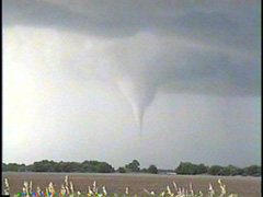
The first tornado I witnessed occurred just southwest of Mulvane KS. The condensation funnel never reached the ground although it did produce a damaging circulation at the surface. The funnel was visible from between 7:09pm to 7:13pm. Click here for more pics. |
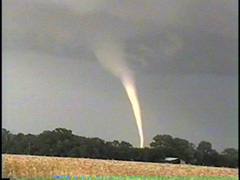
| The second tornado of the day tracked southeast of Mulvane KS between around 7:23pm and 7:35pm. This was the most spectacular tornado of the day, glowing a brilliant white as it became lit by the sun. This tornado did significant damage to at least one house and tossed vehicles up to 1/4 mile away. Click here for more pics. | |
| |
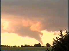
The third tornado tracked east of Rock KS between 8:24pm and about 8:31pm. This tornado moved in a westerly direction for parts of its life cycle, the opposite of the easterly direction most tornadoes travel. Click here for more pics. |
|
|
|
Back to Storm/Chase Summaries
Back to Jeff's Virtual Cyclone Cellar
This page was last updated on 6-16-04 at 1752 CDT