may 7, 2000
hp supercell in southwest nebraska
Our first day of the trip took us into southwestern Nebraska to see some high-precip supercells. Wind shear was favorable for supercells in this area today, but the cap kept storms from firing until the early evening hours. High humidity (dewpoints in the upper 60s to low 70s) really cut down on the visibility and contrast, but we were treated to a nice supercell at sunset and a decent lightning display after dark. On the way back to Colby KS, we drove into the teeth of a low-level jet that fogged up our windows. As we arrived in Colby at midnight, we were greeted with a vigorous frontal passage as the winds went from easterly with gusts to about 30 mph to northerly with gusts to about 45 mph in the span of about 5 minutes.
|
Mother Nature assures us there was good shear in the area by showing us her own version of a curved hodograph - the leaning towering cumulus! As this tower built to the northeast of Lexington NE, we watched southeasterly low-level winds push it northwest, southwesterly mid-level winds push it northeast, then northwesterly higher level winds push it southeast. Now all we need is an updraft strong enough to bust the cap.... |
 |
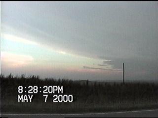 |
We learned that storms had begun to fire to our west, so we headed towards North Platte in hopes of intercepting one before sunset. We encountered this rain-wrapped supercell near Dickens NE at sunset. This storm had some interesting striations and mammatus beneath the anvil, but terrible contrast made photo/video opportunities quite difficult. |
|
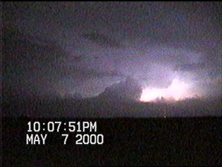
The storms merged into a MCS after dark, so we pulled over south of McCook NE to get photos and video of the lightning. Most of the lightning was of the in-cloud variety, which occasionally backlit this updraft tower. |
 |
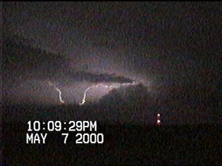 |
A few cloud-to-cloud strikes occurred as well. |
|
Here comes the outflow....it's time to go! |
 |
Go on to the next page.